Sierra Leone (Republic of Sierra Leone), SL
Sierra Leone: Independent country in West Africa
About

Quick Facts about Republic of Sierra Leone
| Population : | 7,557,212 |
| Country : | Sierra Leone |
| Head of government : | Chief Minister of Sierra Leone, President of Sierra Leone |
| Plate code : | WAL |
| Area : | 71740 km2 |
| Official name : | Sierra Leone, la République de Sierra Leone, Repubblica della Sierra Leone |
| Water as percent of area : | 0.2% |
| Land as percent of area : | 99.8% |
| Continent : | Africa |
| Northernmost point : | Point(-11.5 10.0) |
| Legislative body : | Parliament of Sierra Leone |
| Named for : | Lion Mountains |
| Official language : | English |
| Capital : | Freetown |
| Establishment : | April 04, 1971 (54 years ago) |
| Time Zone : | UTC±00:00 |
| Local time : | 04:48:22 (1st July 2025) |


Geography
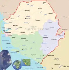
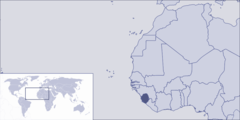
Republic of Sierra Leone is located at 8°30'0"N 11°30'0"W (8.5000000, -11.5000000). It has 2 neighbors: Liberia and Guinea.
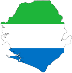
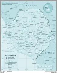
Sierra Leone map
The largest city of Republic of Sierra Leone is Freetown with a population of 951,000. Other cities include, Kenema population 143,137, Port Loko population 21,308, Kabala population 17,948 and Bonthe population 9,647. See all Republic of Sierra Leone cities & populated places.
- Official Website
Official website of Republic of Sierra Leone
David J. Francis ,
Republic of Sierra Leone has 2 neighbours.
- Republic of Liberia Independent country in West Africa
- Republic of Guinea Independent country in Africa
- North West Province
- Southern Province
- Northern Province
- Western Area
- Eastern Province
Demographics
| Year | Population | % Change | Method |
| 1960 | 2,160,111 | - | census |
| 1961 | 2,189,040 | 1.32% | census |
| 1962 | 2,219,498 | 1.37% | census |
| 1963 | 2,251,563 | 1.42% | census |
| 1964 | 2,285,313 | 1.48% | census |
| 1965 | 2,320,858 | 1.53% | census |
| 1966 | 2,358,225 | 1.58% | census |
| 1967 | 2,397,572 | 1.64% | census |
| 1968 | 2,439,310 | 1.71% | census |
| 1969 | 2,483,952 | 1.8% | census |
| 1970 | 2,531,874 | 1.89% | census |
| 1971 | 2,583,200 | 1.99% | census |
| 1972 | 2,637,861 | 2.07% | census |
| 1973 | 2,695,784 | 2.15% | census |
| 1974 | 2,756,810 | 2.21% | census |
| 1975 | 2,820,782 | 2.27% | census |
| 1976 | 2,887,735 | 2.32% | census |
| 1977 | 2,957,599 | 2.36% | census |
| 1978 | 3,029,965 | 2.39% | census |
| 1979 | 3,104,305 | 2.39% | census |
| 1980 | 3,180,237 | 2.39% | census |
| 1981 | 3,255,883 | 2.32% | census |
| 1982 | 3,330,947 | 2.25% | census |
| 1983 | 3,408,340 | 2.27% | census |
| 1984 | 3,492,174 | 2.4% | census |
| 1985 | 3,584,397 | 2.57% | census |
| 1986 | 3,688,492 | 2.82% | census |
| 1987 | 3,800,961 | 2.96% | census |
| 1988 | 3,908,478 | 2.75% | census |
| 1989 | 3,993,016 | 2.12% | census |
| 1990 | 4,042,678 | 1.23% | census |
| 1991 | 4,053,257 | 0.26% | census |
| 1992 | 4,031,730 | -0.53% | census |
| 1993 | 3,991,434 | -1.01% | census |
| 1994 | 3,951,544 | -1.01% | census |
| 1995 | 3,927,105 | -0.62% | census |
| 1996 | 3,919,708 | -0.19% | census |
| 1997 | 3,928,313 | 0.22% | census |
| 1998 | 3,961,869 | 0.85% | census |
| 1999 | 4,030,443 | 1.7% | census |
| 2000 | 4,139,757 | 2.64% | census |
| 2001 | 4,295,667 | 3.63% | census |
| 2002 | 4,493,047 | 4.39% | census |
| 2003 | 4,712,763 | 4.66% | census |
| 2004 | 4,928,175 | 4.37% | census |
| 2005 | 5,119,895 | 3.74% | census |
| 2006 | 5,280,909 | 3.05% | census |
| 2007 | 5,416,015 | 2.49% | census |
| 2008 | 5,532,139 | 2.1% | census |
| 2009 | 5,641,182 | 1.93% | census |
| 2010 | 5,751,976 | 1.93% | census |
| 2011 | 5,865,491 | 1.94% | census |
| 2012 | 5,978,727 | 1.89% | census |
| 2013 | 6,092,075 | 1.86% | census |
| 2014 | 7,017,144 | 13.18% | (Worldbank) |
| 2015 | 7,092,113 | 1.06% | census |
| 2016 | 7,328,838 | 3.23% | (Worldbank) |
| 2017 | 7,557,212 | 3.02% | census |
| 2018 | 7,650,154 | 1.21% | (Worldbank) |
| 2019 | 7,813,215 | 2.09% | (Worldbank) |


