Malaysia, MY
Malaysia: Independent country in Southeast Asia
About

Quick Facts about Malaysia
| Population : | 31,624,264 |
| Country : | Malaysia |
| Different from : | My, Malesia |
| Head of government : | Prime Minister of Malaysia |
| Twitter username : | TourismMalaysia |
| Plate code : | MAL |
| Area : | 330290 km2 |
| Official name : | Malaisie, Malaysia |
| Continent : | Asia |
| Easternmost point : | Point(119.2691 5.2329) |
| Northernmost point : | Point(117.23 7.37) |
| Legislative body : | Parliament of Malaysia |
| Associated foods : | nasi lemak |
| Official language : | Malay |
| Capital : | Kuala Lumpur |
| Establishment : | January 01, 1957 (68 years ago) |
| Time Zone : | UTC+08:00 |
| Local time : | 13:36:02 (1st July 2025) |


Geography
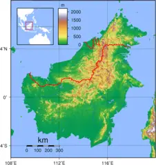
Malaysia is located at 2°30'0"N 112°30'0"E (2.5000000, 112.5000000). It has 5 neighbors: Thailand, Indonesia, Philippines, Brunei and Singapore.
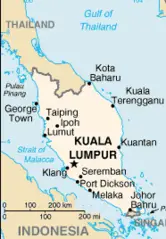
Malaysia map
The largest city of Malaysia is Kuala Lumpur with a population of 7,590,000. Other cities include, Johor Bahru population 802,489, Petaling Jaya population 520,698, Sandakan population 392,288 and George Town population 300,000. See all Malaysia cities & populated places.
- Official Website
Official website of Malaysia
- Muhyiddin Yassin , 2020-03-01T00:00:00Z
- Mahathir Mohamad , 1 March, 2020 2018-05-10T00:00:00Z
Malaysia has 5 neighbours.
- Kingdom of Thailand Independent country in Southeast Asia
- Republic of Indonesia Independent country in Southeast Asia situated on more than 17,000 islands
- Republic of the Philippines Independent country in Southeast Asia
- Brunei Darussalam Independent country in Southeast Asia
- Republic of Singapore sovereign city-state in Southeast Asia
- Kedah
- Selangor
- Johor
- Negeri Sembilan
- Sabah
- Perlis
- Sarawak
- Melaka
- Kelantan
- Perak
- Pahang
- Penang
- Terengganu
- Kuala Lumpur
- Labuan
- Putrajaya
Demographics
| Year | Population | % Change | Method |
| 1960 | 8,160,975 | - | census |
| 1961 | 8,429,369 | 3.18% | 11676830 |
| 1962 | 8,710,678 | 3.23% | estimation process |
| 1963 | 8,999,247 | 3.21% | 11676830 |
| 1964 | 9,287,442 | 3.1% | estimation process |
| 1965 | 9,569,784 | 2.95% | census |
| 1966 | 9,844,116 | 2.79% | estimation process |
| 1967 | 10,111,920 | 2.65% | 11676830 |
| 1968 | 10,375,877 | 2.54% | 11676830 |
| 1969 | 10,640,347 | 2.49% | estimation process |
| 1970 | 10,908,634 | 2.46% | census |
| 1971 | 11,182,078 | 2.45% | census |
| 1972 | 11,460,080 | 2.43% | estimation process |
| 1973 | 11,741,849 | 2.4% | census |
| 1974 | 12,025,930 | 2.36% | estimation process |
| 1975 | 12,311,782 | 2.32% | estimation process |
| 1976 | 12,599,655 | 2.28% | census |
| 1977 | 12,891,715 | 2.27% | estimation process |
| 1978 | 13,191,699 | 2.27% | estimation process |
| 1979 | 13,504,433 | 2.32% | estimation process |
| 1980 | 13,833,739 | 2.38% | estimation process |
| 1981 | 14,180,093 | 2.44% | census |
| 1982 | 14,543,585 | 2.5% | census |
| 1983 | 14,926,976 | 2.57% | estimation process |
| 1984 | 15,333,369 | 2.65% | census |
| 1985 | 15,764,340 | 2.73% | estimation process |
| 1986 | 16,221,767 | 2.82% | census |
| 1987 | 16,703,500 | 2.88% | 11676830 |
| 1988 | 17,202,032 | 2.9% | estimation process |
| 1989 | 17,707,064 | 2.85% | 11676830 |
| 1990 | 18,211,097 | 2.77% | estimation process |
| 1991 | 18,709,963 | 2.67% | census |
| 1992 | 19,205,112 | 2.58% | estimation process |
| 1993 | 19,701,410 | 2.52% | estimation process |
| 1994 | 20,206,546 | 2.5% | 11676830 |
| 1995 | 20,725,374 | 2.5% | 11676830 |
| 1996 | 21,259,831 | 2.51% | 11676830 |
| 1997 | 21,805,835 | 2.5% | 11676830 |
| 1998 | 22,355,057 | 2.46% | 11676830 |
| 1999 | 22,896,048 | 2.36% | census |
| 2000 | 23,420,751 | 2.24% | census |
| 2001 | 23,925,742 | 2.11% | 11676830 |
| 2002 | 24,413,795 | 2% | estimation process |
| 2003 | 24,890,654 | 1.92% | 11676830 |
| 2004 | 25,365,089 | 1.87% | estimation process |
| 2005 | 25,843,466 | 1.85% | estimation process |
| 2006 | 26,327,098 | 1.84% | estimation process |
| 2007 | 26,813,819 | 1.82% | 11676830 |
| 2008 | 27,302,348 | 1.79% | census |
| 2009 | 27,790,324 | 1.76% | estimation process |
| 2010 | 28,334,135 | 1.92% | census |
| 2011 | 28,758,968 | 1.48% | census |
| 2012 | 29,239,927 | 1.64% | 11676830 |
| 2013 | 29,716,965 | 1.61% | census |
| 2014 | 30,018,242 | 1% | estimation process |
| 2015 | 30,331,007 | 1.03% | 11676830 |
| 2016 | 30,684,804 | 1.15% | (Worldbank) |
| 2017 | 31,624,264 | 2.97% | estimation process |
| 2018 | 31,528,585 | -0.3% | (Worldbank) |
| 2019 | 31,949,777 | 1.32% | (Worldbank) |
An Mhalaeisia, Federation of Malaya, Federation of Malaysia, Ma Lai (Ma-lay-xi-a), Ma-lay-xi-a, Malaezia, Malaiezia, Malaisia, Malaisia - Malaysia, Malaisie, Malaisiya, Malaizia, Malaizija, Malajfoeld, Malajsie, Malajzi, Malajzia, Malajzija, Malajzio, Malasia, Malasja, Malasya, Malasía, Malaysi, Malaysia, Malaysia nutome, Malaysien, Malaysiya, Malaysiyaen, Malaysiyän, Malayzia, Malehyia, Maleisia, Maleisie, Maleisië, Maleizje, Malesia, Malesie, Malesii, Malezhiya, Malezi, Malezii, Malezija, Maleziya, Malezja, Malezya, Malezïi, Malàisia, Malájföld, Malásia, Malèsie, Malēsia, Malɛzi, Mã Lai (Ma-lay-xi-a), Orileede Malasia, Orílẹ́ède Malasia, Persekutuan Tanah Malaysia, Persekutuan Tanah Melayu, i-Malaysia, ma lai xi ya, malaizia, malayesiya, malaysyya, maleciya, maleseiy, malesi'a, malesiya, malesya, malleijia, malleisia, malyasiya, malyzya, malzy, mareshia, mejgu'e, mlyshya, mlzyh, prathes maleseiy, Μαλαισία, Малайзия, Малайзія, Малезија, Մալայզիա, מלזיה, مالايسىيا, مالزی, ماليزيا, مالیزیا, ملیشیا, मलयेशिया, मलेशिया, मलेसिया, মালয়েশিয়া, মাল্যাশিয়া, મલેશિયા, ମାଲେସିଆ, மலேசியா, மலேஷியா, మలేషియా, ಮಲೇಶಿಯ, ಮಲೇಶಿಯಾ, മലേഷ്യ, මැලේසියාව, ประเทศมาเลเซีย, มาเลเซีย, ມາເລເຊຍ, མ་ལེ་ཤི་ཡ, མ་ལེ་ཤི་ཡ།, မလေးရှား, მალაიზია, ማሌዢያ, ម៉ាលេស៉ី, マレーシア, 马来西亚, 말레이시아, 말레이지아



.png)


